Velebit is
the largest mountain range in Croatia that
begins in the northwest with the Vratnik mountain pass near the town of Senj and ends 145 km later in the southeast near the source of the Zrmanja river northwest of the town of Knin. It is part of the Dinaric Alps and separates the coast from the region of Lika in the interior.
Velebit has
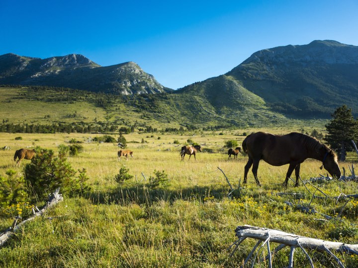
a simple from: 2 slopes falling clearly to each side and a wide top part with steep cliffs,
peeks and karst valleys. Even though Velebit is the largest mountain range in Croatia (145 km) it is
not the highest. The littoral part of Velebit is almost completely rocky and steep, whereas the continental (Lika) part is almost completely covered in forests.
The geological characteristic of the mountains is
karst and the flora and fauna are abundant. The
greatest wealth of flora and fauna can be found in the area of the Northern Velebit National Park. The park is located at the northernmost part of the mountain and covers 109 square kilometres. Here you will find one of the most famous sights of Croatian mountains:
The Hajducki and Rozanski Kukovi - a beautiful range of rocky peaks, up to 200 m high which are protected as a strictly regulated reserve, the strictest form of nature protection in Croatia.
In the n
orthern part of Velebit you will also find the
botanical garden and the pothole Lukina Jama (1475m) - the eighth deepest pothole in the world. Velebit also proud itself with an
endemic plant species - the Velebitska degenija (Degenia velebitica), which is also imprinted on the Croatian 50 Lipa coin.
The
whole mountain range is protected as a nature park and except for the Northern Velebit National Park, the is also the Paklenica National Park in the south part of the range about which we will go into more detail later on.
CLIMATE
Velebit forms
a natural border between the continental and mediterranean climatic regions. The climate is characterised by
extreme and sudden changes in weather.
Velebit’s
climate is harsh, especially in its higher parts but the climate of its coastal and inland slopes differs significantly. The
hiking season is throughout the entire year but you should
be aware of bora, an eastern wind blowing usually during the winter months, that reaches gale force and that can be dangerous because of the cold, sudden onsets of wind and the fog in the higher parts of the mountain. Because of the
possibility of sudden weather changes, you should
bring protection against the cold and rain even during the summer months. The best time for visits is during the summer, because the weather is the most stable then. ´The roads at higher altitudes are usually covered with snow from November until May.
During the summer you should
avoid any ascents from the coastal side, as the are bare and exposed to the sun and it can be unbearably hot.
 HIKING
Velebit has
many well-marked trails and roads for hikers, which are connected to the surrounding places and mountain huts.
The Velebit
hiking destinations are one of the favourite destinations of the visitors of the park, they
range from easy to difficult with views over the Kvarner bay and the islands as well as
of forest and the mountain peaks and valley on the Lika side. Hiking footwear and clothes are needed for all these trails, as well as sufficient quantity of drinking water. Make sure to check the weather forecast prior to hiking.
If you want to get to know this massive mountain through hiking, the
safest and easiest way to do so is to hike along
the Premuziceva trail. The
construction of the trail began in 1930, but due to lack of funds the construction was stopped and
finished in 1933. The trail was c
onstructed and laid out by Ante Premuzic, a passionate mountaineer and forestry engineer after whom the trail was later also got its name.
The trail was
constructed using the drystone technique and is considered to be the most beautiful hiking trail in Croatia. The trail provides t
he easiest access even to the most rugged and difficult to reach sections of Northern Velebit which are the Hajducki and Rozanski kukovi we mentioned earlier. The route is 57 km long and runs partially (16km) through the Northern Velebit National Park. The trail begins in a beech forest below the peak of Badanj at the hamlet of Stupacinovo and takes us all the way to Zavizan in the northern part of Velebit.
The trail
offers beautiful scenic views of the sea and the Kvarner islands. Hikers can also start their tour from Veliki Alan (1414 m above sea level) which is one of the most important Velebit passes over which runs the vertical mountain road that connects Lika with the Adriatic coast. From here one can also enjoy a
stunning view of wide mountain pastures, karst valleys and the slopes with picturesque peeks. This trail requires several days of hiking, but due to the fact that there are almost no steep parts, it is also suited for beginners. Shelter can be found in mountain huts.
 The Southern part of Velebit
 will welcome you with
yet another National Park -
The NP Paklenica (96 km2) where the
karst environment, beech and black pine forests with plenty of flower and plant species meet the highest peeks on the mountain - the Vaganski Vrh (1757 m) and
Sveto Brdo (1751 m). In the
southern part of Velebit we distinguish between
the steep slopes of Lika and
the less steep slopes of the coastal part. The trails on the Lika side are much more comfortable for hiking because of the shade the forests provide and because of the shallow creeks, but be aware to only hike in the marked and recommended areas, as this territory has not completely been cleaned of war mines yet.
The
best hiking trails can be found in Velika Paklenica, while
Mala Paklenica is much steeper, without creeks and rivers and very wild. Because this part is very difficult to access, hiking is only recommended to experienced mountaineers, as experience and knowledge of the mountain are also required.
The
Paklenica National Park is characterised by beautiful karst relief and caves, and due to the climatic conditions, it offers
an abundance of flora and fauna. Despite the wild nature,
Paklenica is easily accessible due to the close proximity to the Adriatic highway and the motorway.
The routes are marked with tables and signs in several foreign languages.
The
hamlet Knezevici is a good starting point where you can buy some delicious homemade honey. :)
Cliffs vertically rising above 400m are the most recognisable feature of the park with the Anica kuk as the biggest rock on Velebit. Paklenica is foremost known as one of the most beautiful and popular climbing destinations for visitors from all over the world because of the mild climate, beautiful nature and fascinating views.
If you want to
hike through the central part of Velebit, head to Krasno (800m), a small
mountain village consisting of 14 scattered hamlets in the picturesque Krasno valley which is surrounded by beautiful forests. You can get more information about the nature park in the village and taste delicious homemade cheese :) Above the village the Sanctuary of The Holy Mother of Krasno is located. Next to the church there is a restaurant with a beautiful scenic view. You can reach Krasno by taking the paved road from Sv. Juraj or by taking the road from Otocac. On business days a bus leaves for Krasno two times per day from the town of Senj.
Near Krasno you will find Kuterevo with a Bear Sanctuary. Both from Kuterevo and Krasno you can reach the Korenski Vrh (1101m). From the peek a beautiful view over the peeks of the central and northern part of Velebit stretches out before you and a great part of Lika is also visible.
Velebit - a mesmerising experience in the middle of Europe that surely will not leave you indifferent and that will invite you to explore all the different facets that nature has to offer. And when you have had enough of hiking and want to relax, our
villas with pool in Dalmatia and Kvarner will offer you all the necessary modern comfort. :)
Monika Pranjic
18.03.2019